Hurricane Erin is the developing headline of the Atlantic season, beginning as Tropical Storm Erin and forecast to strengthen as it tracks west across the tropical Atlantic according to the National Hurricane Center, making it a key focus for tropical storms Atlantic watchers and preparedness planners in the USA.
Erin’s Status Today
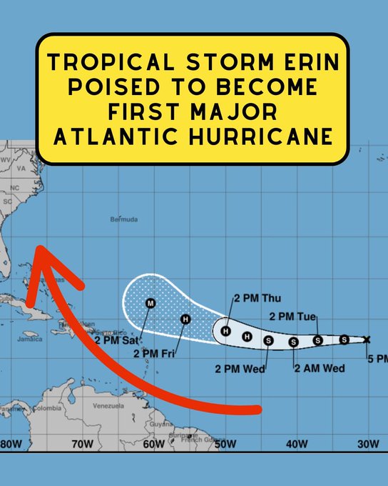
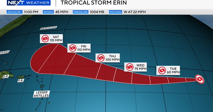
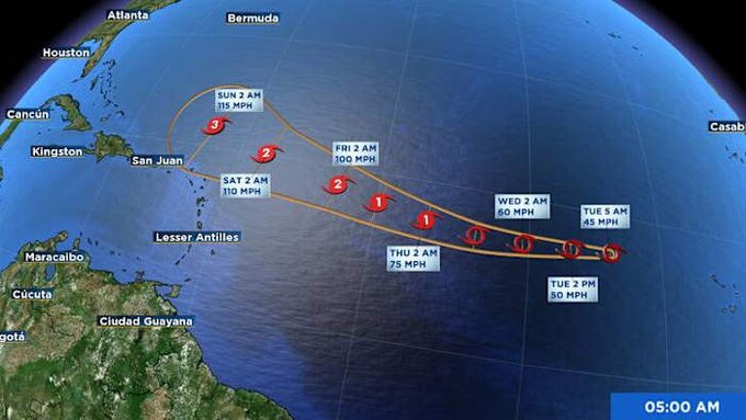
As of the latest advisories, tropical storm Erin hurricane discussions indicate maximum sustained winds near 45 mph, with gradual strengthening expected over the next several days as it traverses warmer waters west of the Cabo Verde Islands. The National Hurricane Center cone shows a steady westward motion under a subtropical ridge with a likely turn to the west-northwest later in the period, while intensity guidance supports hurricane status later this week. A range of media, including significant weather reporting agencies, highlight that Erin might turn into the first hurricane of the Atlantic season, although specific U.S. impacts remain uncertain at this range.
Official Forecast And Track
NHC forecast positions place Erin near 17–18°N latitude moving west at roughly 18–22 mph initially, then slowing slightly as the ridge weakens, with the official track close to the GFS/ECMWF consensus envelope. The 5-day outlook brings the system into progressively warmer waters and lower shear, increasing the probability of intensification into a hurricane and possibly a major hurricane north of the Caribbean by the weekend, per the latest discussions and third-party summaries. The NHC emphasizes that hazardous conditions can occur outside the cone and that confidence in long-range intensity and track has typical day 4–5 errors, so updates should be monitored.
Erin’s Strength Potential
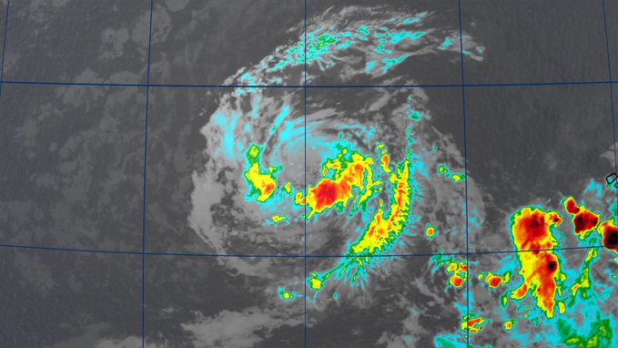
NHC intensity forecasts show Erin organizing more efficiently after 24–36 hours, with the agency noting a faster rate of intensification once sea surface temperatures rise and environmental conditions improve. Multiple media summaries reflect the NHC’s perspective, highlighting a potential first hurricane of the season scenario and the chance of reaching Category 3 intensity if upper-level winds continue to be favorable by Saturday. At present, the system’s core remains compact with tropical-storm-force winds extending outward roughly 45 miles from the center, but that wind field can expand with intensification.

Spaghetti Models And Guidance Spread
For readers tracking hurricane Erin spaghetti models, ensemble plots show near-average spread through 72 hours with divergence emerging by days 4–5 depending on how much the subtropical ridge erodes and where a weakness develops. Model clusters generally favor a west to west-northwest track over the open Atlantic in the short term, with some members bending more poleward later; this is consistent with the NHC track consensus and Weather.com’s multi-map tracker. The takeaway is that guidance supports strengthening over warm water while the track uncertainty beyond five days means interests from the northern Leeward Islands to Bermuda and parts of the U.S. East Coast should follow updates closely.
What It Means For The U.S. Coast
It remains too early to determine direct impacts to the U.S., but stronger storms have broader wind and swell footprints that can bring rip currents and high surf even if the core stays offshore. AccuWeather and national outlets note scenarios where Erin turns north and misses the mainland, and others where peripheral effects could still reach the East Coast from the Carolinas to New England depending on intensity and proximity. NOAA urges using official NHC advisories for decision-making and revisiting hurricane plans as the season nears its climatological peak.
Context Within The 2025 Atlantic Season
Erin represents the fifth named storm in a season that NOAA forecasts to be more active than the average, and it could potentially become the first hurricane if it intensifies as anticipated. The 2025 Atlantic hurricane season is set to take place from June 1 to November 30, and climatologically, the first hurricane usually appears around mid-August, which corresponds with the current expectations noted by national coverage. Early reports also note flooding impacts tied to the disturbance near Cabo Verde prior to designation, underscoring that hazards can occur far from the continental U.S.
How To Read The Cone And Models
The NHC cone reveals the probable route of the storm’s center, but it does not convey the size of the hazardous weather; thus, impacts can take place outside the outlined region if rain bands, winds, or surf extend. Spaghetti models are helpful for visualizing uncertainty but should be interpreted alongside official NHC forecasts, which synthesize models, satellite data, and expert analysis. For real-time visualization, live trackers like Zoom Earth can complement NHC updates with satellite imagery and wind field estimates.

Practical Preparedness Tips
The National Hurricane Center encourages checking kits, prescriptions, batteries, and evacuation routes now rather than waiting for watches or warnings, especially for coastal communities that are sensitive to surge and rip currents. Those in Bermuda, the northern Leeward Islands, the Bahamas, and along the U.S. East Coast should review local guidance and stay tuned to emergency management channels as the forecast evolves later this week. Subscribing to NHC advisories and local NWS alerts helps ensure timely, official updates as the storm’s structure and track change.
Quick Reference: Trusted Resources
- National Hurricane Center advisories and forecast discussions for tropical storm Erin hurricane status and updates.
- NOAA’s 7-Day Tropical Weather Outlook for basin-wide context during active pesriods of Atlantic hurricanes.
- Weather.com offers a comprehensive hub for hurricane maps associated with Erin, showcasing spaghetti models, satellite loops, and sea surface temperature images.
- Live trackers such as Zoom Earth for storm position, wind estimates, and model overlays in one view.
Frequently Asked Questions
What is Hurricane Erin’s status right now? Tropical Storm Erin has sustained winds near 45 mph and is forecast to strengthen over the next few days as it moves west then west-northwest across the tropical Atlantic.
Will Hurricane Erin hit the United States? It is too early to know; the NHC notes near-average confidence in the short term and increasing uncertainty later, with scenarios ranging from a recurvature away from the coast to peripheral impacts depending on intensity and track.
Where can I see Hurricane Erin spaghetti models? Weather.com hosts spaghetti models and layered maps, and trackers like Zoom Earth visualize model consensus and satellite imagery, but always cross-check with the official NHC forecast.

When could Erin become a hurricane or major hurricane? Forecasts suggest hurricane strength late this week and possibly major hurricane status by the weekend if favorable conditions persist, per NHC-guided reporting and analyses.
What are the best official sources to follow? The National Hurricane Center advisories, forecast cones, and discussions on nhc.noaa.gov provide authoritative updates, with NOAA’s 7-day outlook offering broader situational awareness.
Every tropical system evolves, so rely on frequent official updates and local guidance as Hurricane Erin 2025 progresses across the Atlantic.
Read more article please click on the Link.