An intense atmospheric river is driving heavy rain across the Pacific Northwest, and flooding in Washington state has escalated into a widespread emergency that threatens rivers, roads and low-lying communities. Officials activated the state Emergency Operations Center at the highest level and warned more than six million residents to watch for rising water and possible evacuation orders as rivers near historic crests.
What’s happening now: scale and scope of the flooding in Washington state
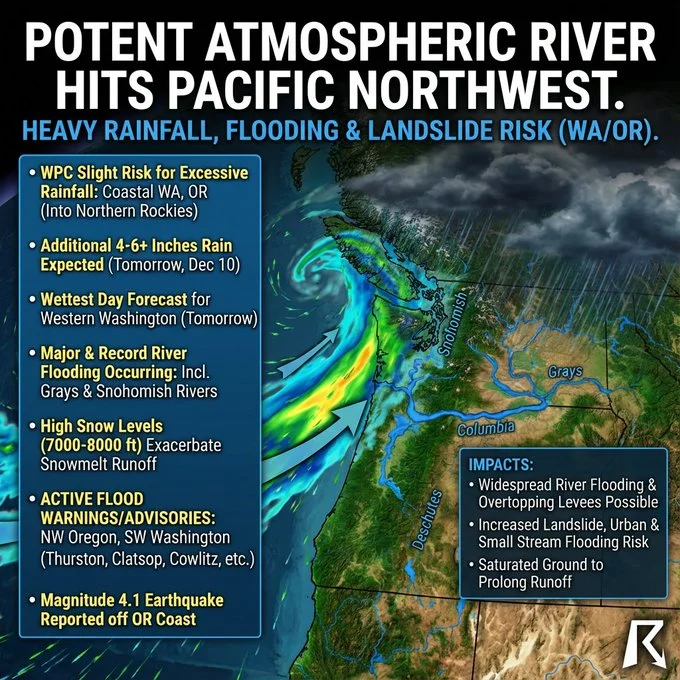
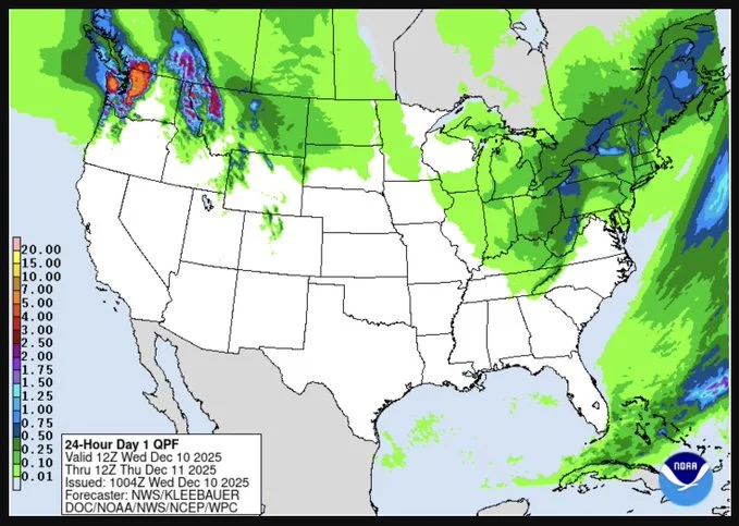
Western Washington, parts of Idaho and western Montana are under flood watches and warnings through the coming days as the storm system dumps several more inches — and in some high-elevation areas over a foot — of rain on ground already saturated by recent downpours. Forecasters expect local totals of more than seven inches in some valleys and 12+ inches at elevation, fueling dramatic river rises and flash flooding that put communities at immediate risk.
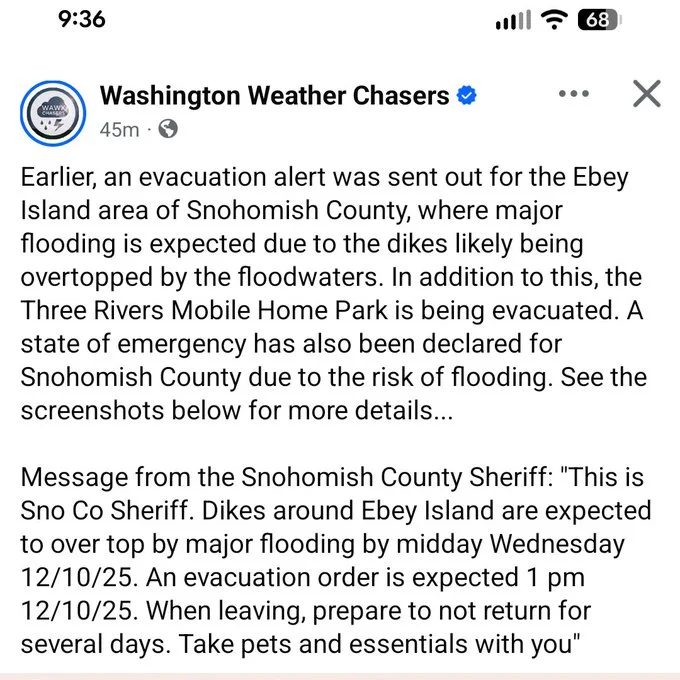
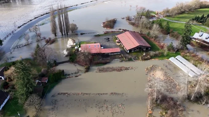
NOAA gauges and local emergency managers show at least 18 river sites in Washington now projected to reach major flood stage, with several rivers forecast to break records. The Skagit River near Concrete is predicted to crest above 47 feet — roughly 15 inches higher than the major-flood threshold and several inches beyond the region’s previous high for that gauge — placing low-lying neighborhoods directly in harm’s way. The Snohomish River is also on track to surge to historic levels, and the Grays River recently recorded a new record crest in Rosburg.

Why the risk is so high
An atmospheric river is a concentrated plume of tropical moisture that streams into a region and produces intense, prolonged rainfall. This event is striking the Pacific Northwest after recent storms left soils saturated and rivers running high; that combination makes runoff far more pronounced and speeds the timing of river rises. Flooding in Washington state is especially acute where steep mountain watersheds funnel runoff into narrow river channels and lowland floodplains, creating powerful surges that can inundate roads, bridges and homes quickly.
Public-safety actions and evacuations
State and local officials urged residents in flood-prone areas to prepare now. Snohomish County declared a state of emergency and activated response plans as river forecasts suggested water levels could exceed historic marks; other counties put emergency shelters and American Red Cross resources on standby to receive displaced families. Authorities in Skagit County notified residents to “prepare for possible evacuation,” and Lewis County fire officials explicitly advised people in vulnerable zones to leave while doing so remains safe.

Firefighters have already deployed inflatable kayaks and other water-rescue gear to retrieve occupants from submerged vehicles, underscoring the sudden danger of rising waters. With many roads already overtopped, officials repeatedly warned drivers not to attempt crossing flooded roadways — a leading cause of flood-related fatalities.
Health and infrastructure threats from flooding in Washington state
Beyond immediate rescues and evacuations, flooding in Washington state threatens critical infrastructure. Low-lying transportation corridors, wastewater treatment plants and electrical substations can be compromised by fast-moving water, creating secondary public-health risks from power loss and contaminated floodwaters. Public-health guidance emphasizes avoiding contact with floodwater, as it can carry sewage, industrial pollutants and sharp debris.
What residents should do now

- Monitor local alerts and NOAA river gauges for your nearest town.
- If you are in a flood-prone area, prepare an evacuation bag (medications, documents, phone chargers, flashlight).
- Move vehicles and valuables to higher ground and unplug electrical appliances if you must leave.
- Do not drive through floodwater; a few inches of fast-moving water can sweep a car away.
- Follow instructions from local emergency managers and shelters if evacuation orders are issued.
Outlook and recovery
Forecast models show the atmospheric river continuing to feed moisture into the region for the next 48–72 hours, meaning river crests and flood impacts could worsen before improving. Emergency teams remain on high alert to respond to new evacuation orders and road closures as predictions update. Once the rains subside, communities will shift to assessing and repairing damage, clearing debris, and supporting displaced residents.
Why this matters
Flooding in Washington state during an atmospheric-river event demonstrates how quickly extreme-rainfall systems can overload rivers and floodplains — especially after repeated storms leave soils saturated. Officials stress preparation, heeding evacuation notices and avoiding floodwaters to reduce risk to life and property.