The Canyon Fire is one of the most severe wildfires blazing across California in 2025, primarily impacting areas around Lake Piru, Ventura County, and Los Angeles County. This fire has led to several evacuation orders and continues to spread rapidly due to hot, dry weather and strong winds. In this article, we bring you the latest updates on the Canyon Fire today, essential information about the affected regions like Santa Clarita and Castaic, and the overall situation in Ventura County.

Overview of the Canyon Fire
The Canyon Fire ignited around 1:30 PM on August 7, 2025, near Holser Canyon Road, east of Lake Piru in Ventura County. Within hours, it expanded from an initial 30 acres to nearly 5,000 acres, fueled by dry brush and high temperatures reaching 100 degrees Fahrenheit. Rapid wind-driven spread pushed the blaze eastward into Los Angeles County, particularly threatening communities such as Val Verde, Castaic, and areas adjacent to Interstate 5.
Evacuations and Safety Measures
As a result of the rapid expansion of the Canyon Fire, mandatory evacuation orders have been implemented for multiple zones:
- Ventura County: Level 3 evacuation orders for residents near Lake Piru. Level 2 evacuation warnings extend to neighboring districts.
- Los Angeles County: Evacuations in regions including Santa Clarita, Castaic, and Val Verde. Around 2,500 residents and over 700 structures are under mandatory orders, with an additional 14,000 people under evacuation warnings.
- Emergency officials urge residents in these areas to heed warnings promptly to ensure safety.
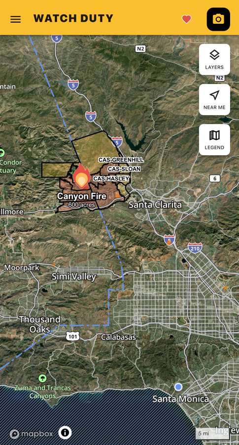
Canyon Fire Map: Tracking the Fire
Tracking the Canyon Fire is crucial for residents and emergency responders. Fire authorities use detailed maps showing current containment status, fire perimeter, evacuation zones, and areas under warning. Updated maps are available via Ventura County Emergency Services and Los Angeles County websites.
🔥The Canyon Fire in Southern CA exploded to nearly 5,000 acres in hours, forcing evacuations across Ventura & Los Angeles counties.
Meteorologist @MikeLindenWX breaks down the setup that fueled its rapid growth & shows you how to track wildfires in real-time with MyRadar. pic.twitter.com/40MG3IjxeR— MyRadar Weather (@MyRadarWX) August 8, 2025
Impact on Lake Piru and Surrounding Communities
Lake Piru and its neighboring areas are significantly affected. The fire’s proximity threatens recreational sites and residential zones, adding concern for tourism and local ecosystems. Emergency officials continue to monitor the fire’s movement closely to prevent further spread toward populated locations.
Response and Firefighting Efforts
Over 250 firefighters, combined with fixed-wing aircraft and helicopters, are actively battling the fire. Firefighters from Ventura and Los Angeles counties are collaborating under a unified command to control the fire. Cooler nighttime temperatures and reduced wind speeds have allowed for better progress during overnight hours.
Connection to Other California Fires in 2025
The Canyon Fire is part of a series of devastating California wildfires in 2025, influenced by severe drought conditions and climate change. Earlier this year, wildfires such as the Eaton and Palisades fires devastated thousands of acres in Southern California, heightening awareness regarding the frequency and severity of wildfire seasons.
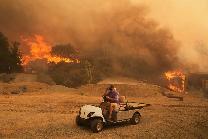
Table: Canyon Fire Key Facts
| Factor | Details |
| Start Date | August 7, 2025, 1:30 PM |
| Location | Near Holser Canyon Road, Lake Piru, Ventura County |
| Burned Area | Nearly 5,000 acres (as of August 8, 2025) |
| Containment | 0% (as of report) |
| Evacuations | Mandatory for 2,500+ residents, warnings for 14,000+ |
| Impacted Areas | Lake Piru, Santa Clarita, Castaic, Val Verde |
| Firefighting Resources | 250+ firefighters, 11 fixed-wing aircraft, 7 helicopters |
| Weather Conditions | Temperatures near 100°F, winds up to 25 mph |
Frequently Asked Questions (FAQ)
What is the current status of the Canyon Fire today?
As of August 8, 2025, the Canyon Fire has burned nearly 5,000 acres with 0% containment. Emergency crews are actively fighting the fire as it spreads east toward Los Angeles County communities.
Where is the Canyon Fire located?
The fire started near Holser Canyon Road, east of Lake Piru in Ventura County, California, and has spread into parts of Los Angeles County near Castaic and Val Verde.

What areas are under evacuation orders due to the Canyon Fire?
Mandatory evacuation orders encompass certain areas of Ventura County near Lake Piru, as well as neighborhoods in Los Angeles County such as Santa Clarita, Castaic, and Val Verde.
In what ways can residents keep themselves informed about the Canyon Fire?
Residents should monitor Ventura County Emergency Services and Los Angeles County emergency websites for updated evacuation maps and alerts.
What caused the Canyon Fire?
The exact cause is under investigation but dry conditions, heat, and wind have contributed to the rapid spread.
How does the Canyon Fire relate to other California fires in 2025?
It is part of a severe wildfire season exacerbated by drought and climate change, with prior notable fires occurring earlier in the year in Southern California.

The Canyon Fire exemplifies the persistent issue of wildfires in California, exacerbated by increasing temperatures and arid conditions. With thousands evacuated and firefighting efforts in full force, this event remains a major headline in the latest trends affecting the USA’s environment and safety in 2025. Stay alert, stay informed, and prioritize safety as the situation develops.
Read more article please click on the Link.