Coastal flood warning is a critical alert issued by the National Weather Service to warn residents about imminent or ongoing flooding caused by water pushed onto land from nearby bodies of water. In 2025, millions across the U.S. East Coast are facing coastal flood warnings, advisories, and watches due to Hurricane Erin—a fast-intensifying storm threatening lives and property from North Carolina to the Mid-Atlantic states. This article breaks down what coastal flood warnings mean, their differences from advisories and watches, and provides the latest updates on Hurricane Erin’s projected path, tropical storm warnings, and possible impacts.
- What Is a Coastal Flood Warning?
- Coastal Flood Advisory vs. Coastal Flood Watch vs. Coastal Flood Warning
- Hurricane Erin 2025: Projected Path and Updates
- Table: Hurricane Erin Key Facts and Coastal Flood Alerts
- Tropical Storm Warning and Coastal Flood Watch Explained
- North Carolina Hurricane and Emergency Measures
- Understanding Hurricane Tracker Tools
- Highlight Points: Coastal Flood Warning and Hurricane Erin
- FAQ: Common Questions About Coastal Flood Warning and Hurricane Erin
What Is a Coastal Flood Warning?
A coastal flood warning means moderate to major flooding is occurring or is imminent along coastlines. It is the most serious level of alert regarding coastal flooding, indicating water has already overflowed dune lines and barriers, threatening life and property. Coastal flooding is typically caused by storm surges accompanying hurricanes, tropical storms, nor’easters, or high tides combined with severe weather.
This warning urges residents in vulnerable coastal areas to take immediate action to protect themselves and their belongings. Unlike a coastal flood advisory—which signals nuisance flooding without serious threat—a warning denotes potentially dangerous conditions requiring preparedness and possible evacuation.
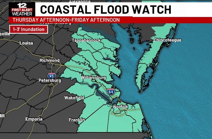
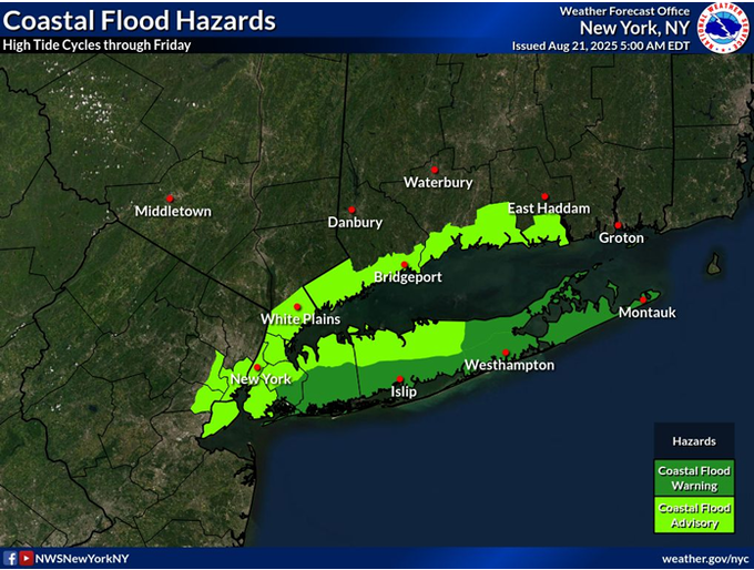
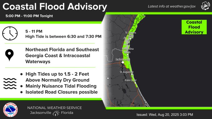
Coastal Flood Advisory vs. Coastal Flood Watch vs. Coastal Flood Warning
- Coastal Flood Advisory: Minor flooding causing inconvenience but not posing serious risks.
- Coastal Flood Watch: There may be moderate to significant flooding expected.
- Residents are encouraged to stay alert and prepared to take action.
- Coastal Flood Warning: Moderate to major flooding is happening or expected. Immediate protective measures are needed.
Hurricane Erin 2025: Projected Path and Updates
Hurricane Erin marks the first significant hurricane of the 2025 Atlantic season. As of August 20, Erin is a Category 2 storm with sustained winds near 110 mph, moving northward near the U.S. East Coast but remaining offshore. While it is not expected to make direct landfall in the mainland U.S., its large size causes life-threatening surf, rip currents, and coastal flooding along the East Coast, especially in North Carolina and Virginia.

The storm threatens waves up to 20 feet, beach erosion, flooding of roads and homes, and hazardous conditions prompting evacuations in the Outer Banks and other vulnerable areas.
Table: Hurricane Erin Key Facts and Coastal Flood Alerts
| Fact | Details |
| Hurricane Category | Category 2 (near Category 3) |
| Sustained Winds | 110 mph |
| Location (Aug 20, 2025) | ~295 miles south of Cape Hatteras |
| Coastal Flood Advisory Areas | East Coast (NC, VA, Chesapeake Bay) |
| Potential Wave Heights | 15-20 feet |
| Tropical Storm Warnings | Parts of North Carolina & Virginia |
| Evacuations | Outer Banks (Ocracoke & Hatteras islands) |
Tropical Storm Warning and Coastal Flood Watch Explained
Tropical storm warnings indicate sustained winds of 39-73 mph in affected zones, often accompanying heavy rainfall and flooding. Coastal flood watches warn that flooding is possible and that residents should prepare to move to safety if conditions worsen.
North Carolina Hurricane and Emergency Measures
North Carolina declared a state of emergency ahead of Hurricane Erin’s approach. The Outer Banks islands faced mandatory evacuations along with ferry evacuations. Officials urged residents to have emergency kits ready and avoid waterfronts due to the risk of life-threatening surf and flooding.
Understanding Hurricane Tracker Tools
Hurricane tracker tools provide live satellite data, wind speeds, and forecast paths for storms like Erin. Tracking keeps residents and authorities informed of changing conditions, helping with timely warnings and preparation.

Highlight Points: Coastal Flood Warning and Hurricane Erin
- Coastal flood warning indicates imminent or occurring moderate to major flooding, posing serious risk.
- Hurricane Erin 2025 is a Category 2 hurricane threatening East Coast with flooding and dangerous surf.
- North Carolina and Virginia are under tropical storm and coastal flood watches with evacuations in place.
- Coastal flood advisory is less severe than warning, signaling minor nuisance flooding.
- Residents are encouraged to keep an eye on hurricane tracker updates and follow local emergency guidelines.
FAQ: Common Questions About Coastal Flood Warning and Hurricane Erin
Q: What is the difference between coastal flood advisory, watch, and warning?
A: Advisory is minor flooding, watch means flooding is possible, and warning means moderate to major flooding is happening or imminent.
Q: Where is Hurricane Erin expected to impact?
A: Mainly the U.S. The East Coast, particularly the Outer Banks of North Carolina, along with certain regions of Virginia and the Chesapeake Bay areas.
Q: Is a coastal flood warning a serious alert?
A: Yes, it signals flooding that threatens life and property with water already intruding on land or about to.
Q: What should residents do during a coastal flood warning?
A: Prepare emergency kits, follow evacuation orders if given, avoid floodwaters, and stay updated through official sources.

Q: Does Hurricane Erin pose a direct landfall threat in 2025?
A: No direct landfall is expected, but the storm’s size and waves will cause coastal flooding and hazardous conditions.
Understanding coastal flood warnings and storm updates like those from Hurricane Erin helps communities stay safe during extreme weather. Following expert guidance ensures preparedness amid changing coastal conditions along the USA’s shorelines.
Read more article please click on the Link.